Terrestrial laser scanning with HDR imaging.
Open research dataset · 2026Terrestrial LiDAR · 3D scene understanding
Expert Systems with Applications · Co-first author
Semantic
Urban.
Towards Accurate Urban Scene Understanding using Point Clouds: The SemanticUrban Dataset
150Urban scenes
≈4BLabelled points
23Semantic classes
4Chinese cities
01 · Overview
Cities,
point by point.
A benchmark designed around the detail, scale and annotation accuracy required by real urban perception systems.
A high-resolution view of the urban world where every visible surface can become machine-readable structure.
Point clouds are essential representations of three-dimensional surfaces in real scenes and objects. Yet benchmark datasets for urban understanding have often been constrained by limited semantic detail or imprecise object boundaries.
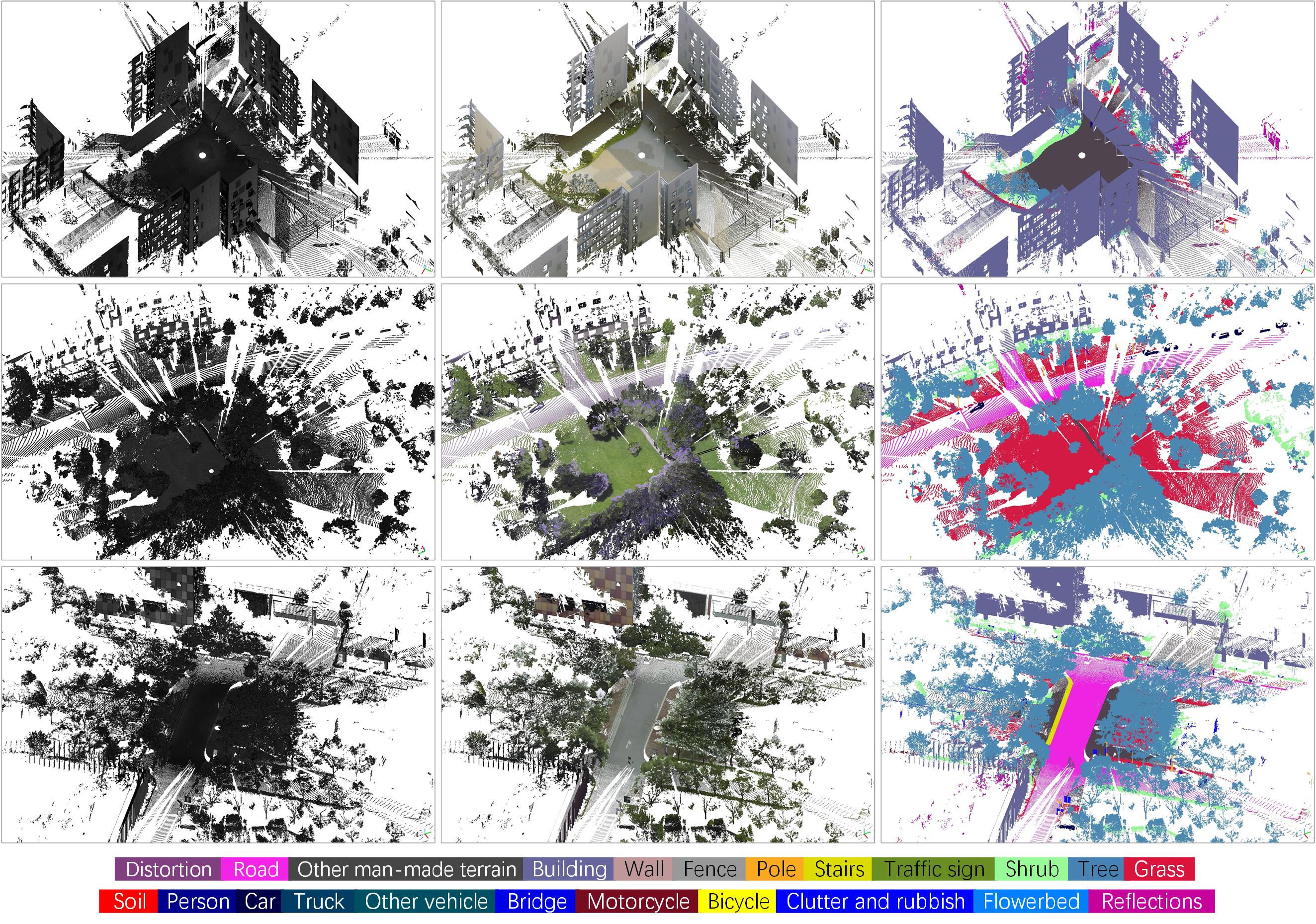
SemanticUrban addresses this gap with 150 terrestrial laser scanning scenes and approximately four billion manually labelled points. Each point belongs to one of 23 classes, combining super-high-resolution geometry with accurate semantic categorisation, intensity and RGB information.
Representative deep-learning methods are evaluated on the benchmark, revealing challenges that motivate more accurate, scalable and detail-aware approaches to 3D urban scene understanding.
02 · Dataset architecture
Scale without
losing detail.
Horizontal and vertical sensor coverage.
Geometry, intensity and colour for every released point.
Official train, validation and test scenes.
Fine objects and boundaries remain visible rather than disappearing during coarse aggregation.
A preprocessed version for reproducible training and evaluation; raw data is available by request.
03 · Semantic taxonomy
Twenty-three classes.
One coherent city.
DistortionRoadOther man-made terrainBuildingWallFencePoleStairsTraffic signShrubTreeGrassSoilPersonCarTruckOther vehicleBridgeMotorcycleBicycleClutter and rubbishFlowerbedReflections
04 · Annotation precision
Boundaries that
hold up close.
05 · Scene gallery
Annotated
urban worlds.
06 · Access
Enter the
benchmark.
Code, processed data and documentation.
The official repository contains download links, data organisation, benchmark split and usage instructions.
Need the original scans?
The public package is the 0.05 m voxel benchmark. Researchers can request raw data from the corresponding author.
07 · Citation
Build on
this work.
@article{FANG2026132949,
  title   = {Towards Accurate Urban Scene Understanding using Point Clouds: The SemanticUrban Dataset},
  author  = {Yuan Fang and Qinfeng Zhu and Yuanzhi Cai and Lei Fan},
  journal = {Expert Systems with Applications},
  pages   = {132949},
  year    = {2026},
  issn    = {0957-4174},
  doi     = {10.1016/j.eswa.2026.132949}
}